Aerial Survey and Mapping
Did you know that precision aerial mapping can:
- Save you money - up to 40% versus traditional survey methods.
- Save you time - typical UAS aerial data collections can take less than an hour for a 100-acre site.
- Increase your accuracy - precision aerial mapping produces millions of points vs. a few thousand when compared to traditional ground surveys.
If you have been thinking about using Unmanned Aerial System (UAS) to perform precision aerial mapping and take your business to new heights, we have the products and expertise to help you succeed.
A Fully-Integrated Solution
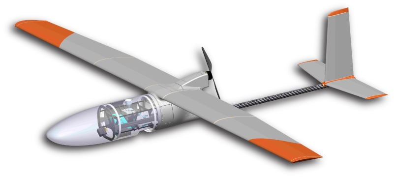
A sUAS solution from Black Swift Technologies is a fully-integrated solution consisting of the aircraft (airframe) and mission planning software specially engineered from inception to work in concert for the most efficient, reliable, and accurate aerial mapping platform available. For precision aerial mapping and detailed photogrammetry missions you will likely nd that this is the only system that you need. For more complex missions our team has unmatched expertise in system design and integration. We can help you select and integrate an efficient system combining the right airframe and sensor suite with our flight management system.
Typical Deliverables
|
|

|
Professional Surveyors and Engineers carry the durable SwiftTrainer with them to the job site and can hand launch the drone for their surveying and aerial mapping jobs. The SwiftTrainer can be programmed in minutes to calculate the area under review and then begin collecting the data for immediate analysis and decision making. Using your choice of survey or engineering processing software, you can develop outstanding 2D orthomosaic and 3D point cloud maps with accuracy traditional methodology cannot match.
A Turnkey Solution
While the process of gathering aerial data is easy, generating useful precision aerial mapping deliverables involves expertise in multiple disciplines including: aviation, surveying, photography, photogrammetry, ASPRS accuracy standards, geodesy, and finally engineering. For those who don't want to invest the time and money necessary to understand the intricacies regulating commercial drone applications and FAA Part 107, Black Swift Technologies has partnered with UAS service providers that have the qualifications and expertise to deliver survey-grade accuracy to civil engineering and survey professionals using precision aerial mapping. Contact us to learn more.Delivering Real Results
Our customers rely on our sUAS solutions for the accuracy and efficiency they have come to expect from BST.
Read about these real-life solutions and discover how BST can help take your business to new heights.